World Map of Ibn Hawqal , 980 A.D. , Abu al-Qasim Muhammad ibn Hawqal
The earliest set of maps to survive from the corpus of Islamic cartography are those that accompany the text Kitab surat al-ard [Picture of the Earth] of Abu al-Qasim Muhammad ibn Hawqal [Haukal] in the manuscript dated 1086, found in the Topkapı Sarayı Müzesi Kütüphanesi in Istanbul.
Ibn Hawqal's life has come down to us in considerable detail mainly because he was more open about himself in his book. He was born in Nisibis in Upper Mesopotamia and spent much of his life traveling, setting out on 15 May 943 and continuing on and off until 973, when he last appears in Sicily. Between these dates he covered most of Islamic Africa and large areas of Persia and Turkestan. It is possible that he acted as a trader on his travels, since his work is full of facts relating to economic activity. That he extols the Fatimid religious policy may mean he was a da'i or missionary of that sect, and this would be another reason for his moving constantly from place to place. Apart from a short work on Sicily, he is known only for his one geography book, Kitab surat al-ard, also known as Kitab al-masalik wa-al-mamalik..
The main difference between the work of Ibn Hawqal and that of al-lstakhri is in the former's discussion of the western (formerly Byzantine) part of Islam. He treats Spain, North Africa, and Sicily as three separate sections. Syria and Egypt are dealt with in more detail, and it is interesting that when later authors like Yaqut quote Ibn Hawqal they are almost always referring to these western regions.
Al-lstakhri's work was a commentary on the maps, and he states that "our plan is to describe, and to delineate on maps, the various seas, ... affixing the name of each, so that it may be known in the maps," thus showing the importance he placed on the maps. The cartography, therefore, was still the essential element in the work.
He was also interested in the composition of the maps, and at his meeting with Ibn Hawqal they compared their maps. Ibn Hawqal states that al-lstakhri
had drawn a map of Sind, but he had made some mistakes, and he had also drawn Fars, which he had done extremely well. For my part, I had drawn the map of Azerbaijan which occurs on the following page and of which he approved, as well as that of al-Jazirah which he considered excellent. My map of Egypt, however, he condemned as wholly bad and that of al-Maghrib as for the most part inaccurate.
Because he states in the text that the map "occurs on the following page," he lets it be known that the map the reader sees is the one he drew himself.
Ibn Hawqal's text as we know it today is again the result of three versions-a first redaction from about 961 dedicated to the Hamdanid Sayf al-Dawlah (died 967), a second redaction containing criticism of the Hamdanids from about a decade later, and a final definitive version from about 988. Ibn Hawqal himself seems originally to have wished to produce a set of maps, but he was carried away by his commentary, and this becomes much more voluminous and interesting than that of al-lstakhri, while to the ordinary reader the map loses its importance because of its inadequacy. All this shows, however, that the map is linked directly to the scholar in each case and not added by the copyist, as are many illustrations to manuscript books or even early printed books, which thus had a completely different provenance than the text.
Ibn Hawqal goes one stage further than al-lstakhri. In addition to his text on a particular region, he also inserts a section that describes the map literally in the simplest terms. Whether this is meant to be an aid for the cartographer is difficult to say. This description can be understood only in conjunction with the map itself and does not add to the information in the main text. The section can easily be deleted without affecting the rest of the text. An example from the section on Kirman begins:
Explanation of the names and legends that are found on the map of Kirman. The sea appears at the top of the map; to the right of this is [the legend] "The map of Kirman," then in the corner the word "West" while in the corner on the left is the word "South." Then there begins to the extreme right of the sea, going down [the page] an inscription, stretched out round the three sides of the map which says "Boundary of Kirman . . ."
What one really wishes to know is how close to the original version of these scholars is the map we see in a manuscript produced several centuries after the death of the scholar himself. This is very difficult, since probably only one of the manuscripts now extant was produced within two hundred years of the original map it was taken from. Kramers, however, has attempted to classify the surviving manuscripts using the state of the maps as his criterion. This he finds fits the state of the text as well and agrees with the comments de Goeje made about them.
Kramers finds that the texts presumed to be by al-Istakhri can be divided into two groups, and he regards one as earlier in origin. In this earlier group (Istakhri I), the maps are more geometric than the later ones (Istakhri II), while the text that goes with the later maps is more finished and polished. On the other hand, it is the earlier texts that mention the name al-lstakhri, so that Miller attributes the anonymous (Istakhri II) texts to al-Balkhi , presuming wrongly that they are earlier than the others.
The era of Arab cartography during which Ibn Hawqal worked is characterized by collections of distinctive maps accompanying geographical treatises, although these treatises are mostly alike in both the number of maps and the information they contain. During this time they no longer show any trace of the influence of European cartography and represent somewhat of a decline also in the influence of Claudius Ptolemy. The maps produced during this time were primarily artistic and ingenious schematic drawings. Compasses, ruler, and set square produced the necessary geometrical figures. Some of the maps were skillfully constructed and stylized itineraries, showing roads and towns, but without any indication of distances; while some were highly schematic world pictures. Because of the peculiar character of these groups of maps and their overall similarity, they have been called the Atlas of Islam. An atlas of this type usually consisted of 21 maps: a world map, 3 sea-charts (the Mediterranean, the Persian Gulf, and the Caspian), and 17 maps of separate Islamic countries; with a text of "standard content". These atlases probably stem from one man's work, which underwent changes as it was copied. Four known authors who drew from these maps for their writings were Abu Zaid al-Balkhi (919-921), the first to do so, al-lstakhri (Alestakhry, 934), Ibn Hawqal (980), and al-Muqaddasi (985). These maps were later used as models by other Arab and Persian cartographers who added much to them, as well as altering their appearance.
Ibn Hawqal's treatise, The Book of Roads and Provinces, is a documented derivative. While traveling in the valley of the Indus, Ibn Hawqal met al-lstakhri and this is a description of that fateful meeting:
He (Istakhri) showed me the geographical maps in his work, and, when I had commented on them, he gave me his work with the words, 'I can see that you were born under a lucky star, therefore take my work and make such improvements as you think fit'. I took it, altered it in several particulars, and returned it to him.
For both works we have the same divisions of subject-matter, and the same number of chapters; the very expressions are often identical. But the account of Ibn Hawqal is more literary and more developed; as might be expected from a native of Bagdad who, from 943 to 969 seems to have been travelling incessantly, though presumably, within the limits of Islam. Some of his other sources for the treatise include Ibn Khordadbeh, Kodama, and Aldjayhany. In the beginning of his work, Ibn Hawqal outlines the scope of his objective:
I have described the earth in its length and breath; I have given a view of the Moslem provinces, but I have taken no account of the division of climates, in order to avoid confusion. I have illustrated every region by a map. I have indicated the position of each, relative to other countries. The boundaries of all these lands, their cities and cantons, the rivers that water them, the lakes and pools that vary their surface, the routes that traverse them, the trades that flourish in them - all these I have enumerated: in a word, I have collected all that has ever made geography of interest either to princes or to people.
However, there are certain exceptions, Ibn Hawqal tells us later, which he felt it necessary to make.
I have not described the country of the African blacks and the other peoples of the torrid zone because, naturally loving wisdom, ingenuity, religion, justice, and regular government how could I notice such people as these, or magnify them by inserting an account of their countries ?
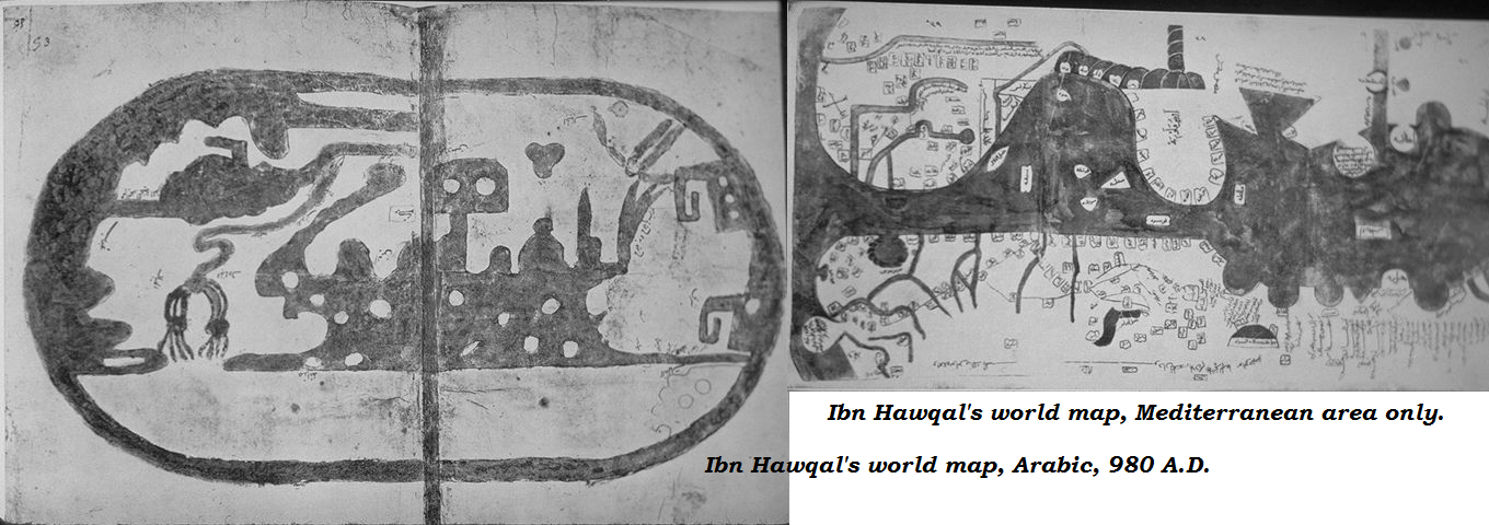
The world depicted on the above illustration is a disc-shaped earth surrounded by ocean, with two deep bays cutting into it - from the east, the Persian Gulf with the Red Sea and the Arabian Sea, and from the west, the Mediterranean Sea. Again, it can be seen that the lines of the map are very stylized and geometrical as those found on Istakhri's world map . The other map of Ibn Hawqal's illustrate a much less stylized picture of the world, but does include a circumfluent ocean, an almost land-locked Indian Ocean (after Ptolemy), and an interesting and speculative West African coastline, hinting at the Gulf of Guinea. The Nile River seems to be the only river system deemed worthy of illustration. Distortion of Europe is great with Italy laying east-west. Particularly of interest here is the inclusion of the Antipodes or Southern Continent.
Some sampling of the details of the text of Hawqal's treatise will reveal some of the geographical philosophy/theory that was so prevalent among the Moslem world in the late 10th century. In his description of the Caspian Sea region, he states:
The Western side of this sea belongs to Deilman and Taberistan and Gukan, and its borders; and part of it is bordered by the deserts of Khuarezm. On the Eastern side is Aran and Moukan and the territories of Serir and part of the deserts of Azziah: and on the north it has the desert of Azziah, to the territories of Siah Kouh: and on the south, Bakeil and Deilman and the neighboring places. This sea is not connected with any other; and if a person wishes to make a tour completely round it, nothing will impede him but a few rivers which fall into it from various quarters. The waters of this sea are bitter and dark-colored: its bottom is blackish sea, differing in this respect from the Sea of Kolzum [Red Sea] or of Oman or of Pars [Persian Gulf]. This Sea of Pars is of such clear water that one may see the white stones at the bottom; but the waters of this Sea of Khozr [Caspian Sea] are dark-colored, and in it there are not found any such things as pearls, or coral or similar marine productions. It is, however, much frequented by the ships of merchants who traffic from one town to another: but there are many trees and forests. One island is considerable, with a spring of water, and many trees: and there is another large island on the borders of Lekzan, which also has fresh water. In this ocean there are not any inhabited islands as in the Sea of Pars or of Roum [Mediterranean Sea]: but it affords much fishing. To the island bordering Lekzan they bring cattle from Berdaa in boats, and turn them out to graze and leave them until they become fat.
In addressing details, the region of Islam is defined as superior to others in that it is more extensive; bordering alike upon the northern and southern ocean is pathless desert, but inhabited and cultivated ground stretches along the diameter of the world, from China to Morocco. Of great inland seas, the Persian Gulf and the Mediterranean communicate with the outer ocean, but not the Caspian. Ibn Hawqal avoids the trap into which stumbled so many Latin geographers, and describes how one may make the circuit of this great salt lake without ever quitting terra firma except for the crossing of rivers. The extent and number of the tribes of Gog-Magog (in Turkestan) were known "only to God". Wherever he leaves the Caliphate, Ibn Hawqal is vague and uncertain. Sometimes he is downright fabulous, or rather Koranic, as in his story of the tribe of Russian Jews who were turned into monkeys for hunting on the Sabbath. Here and there, however, he preserves interesting and trustworthy notices of the outside world, as in his account of the gold mines and, still surviving, Christianity of Nubia; of the white race scattered among the blacks of the Zanzibar coast (these were doubtless the Arabs of the Emosaid migration); of the idol of Moultan in Scinde, and of the habits of the Tartars of the Volga. When he tells us that the Nile flows from the east to Fostat [Cairo], he repeats the language of earlier writers who were thinking of the freshwater canal from Suez to Babylon. In a similar way his language on the Nile sources is suspiciously like certain of the Greek and Latin expressions, as to the mysterious river springing out of a cavern near the land of Zanzibar, in a place that could be approached, but never quite arrived at.
An Arabic wheel-map, that of Abu Ishaq al-Farisl al-lstakhri and Abu al-Qasim Muhammad ibn Hawqal (950 to 970). Re-oriented with North at the top, it clearly shows the strong tendency to geometrical stylization characteristic of the second period of Arab cartography. In the original, east was at the top, just as in the T-O maps of contemporary Latin Europe, but instead of the Earthly Paradise the Arab scholars knew enough to place in the Furthest East both China and Tibet. Note also how the tip of Africa points eastwards, a mistake which the Chinese geographers were the first to correct (from Needham after Reinaud).
Of all the countries of Islam, but especially of Mesopotamia and the region of Samarcand, Ibn Hawqal has clear and fairly accurate ideas. Very curious and valuable are his notices of the contemporary travels of the men of Tarsus, and of the inns or caravanerais reserved for them in every great city of Islam, as well as of the fire-temples still existing in Persia; of the trade and manufactures of the Levantine Moslems, and of the wealth of ports like Siraf, where "some traders were possessed of four millions of dinars, and some of more; and yet their clothes were like the clothes of hired laborers". To Ibn Hawqal, the pearl of the earth was Samarcand; although he draws a picture of peace and prosperity in almost every region from the Nile to the Oxus, and from the Taurus to the Pamir. But in Sogd there is something better than the best. "In all the world there is no place more delightful or more health-giving than these three: the Plain of Samarcand, the Oasis of Damascus, the Valley of the Aileh". But the last two do not satisfy Ibn Hawqal. "A fine prospect ought to fill the view completely, and nothing should be visible but sky and verdure." Now Damascus and the Aileh, though beautiful, are of small extent, and encircled by desert;
but the Sogd, for eight days' journey, is all full of gardens and orchards and villages, cornfields and villas, running streams, reservoirs, and fountains both on the right-hand and on the left; and if one stood on the old castle at Bokhara, one could not see anything but rich country as far as the eye could reach, even to the horizon, where the green of the earth and the azure of the heavens were united.
The people were suited to the land. They spent their money in improving the roads, in building caravanerais, in repairing bridges. "Such was the hospitality of the inhabitants, that one would imagine all the families of the land were but one house." In some dwellings the doors were nailed back against the walls, and had been so for a hundred years or more, so that no stranger should ever be denied admittance. Food and lodging were to be had for money in above 2,000 inns, without recourse to the generosity of private citizens; yet every peasant allotted a portion of his cottage for the reception of a guest, and the greatest pleasure of the owner was in persuading a stranger to accept his house. By contrast with this, we may notice how on another frontier of Islam, at Derbend under the Caucasus, life was less tranquil; for the savage Tartar enemies of the city, living all around it, were "as numerous as the waves of the sea that come up to its walls". Fortunately at Atel on the Volga, the townsmen had some allies - a Jewish king, a tribe of Christian Bulgarians, and a number of Mussulman merchants. But taken altogether, Ibn Hawqal's description portrays Islam at a time of singular prosperity. Even in Ferghanah, where Moslems were obliged incessantly to watch the motions of the Turkish hordes beyond Khokand, were groves and gardens and orchards, and flourishing towns with rich bazaars, many acres of land sown with corn, and furnished with windmills and watermills, that were not known in Europe until the first Crusade.
(Ibn Hawqal I, Topkapi Sarayi Müzesi Kütüphanesi, (A. 3343), Istanbul, Turkey.
bn Hawqal II, Bibliotheque Nationale, Paris, MS. Arabe 2214, fols. 52v-53.)


al-Kashgari's world map,
from the Diwan lughat al-Turk, 1076 A.D.
 |
| Ibn al-Wardi world map, 1001 A.D. oriented with South at the top |


devam ediyor
***